Hardwares
WindCube V2 Offshore
Il WINDCUBE® v2 Offshore is the most flexible and convenient solution to perform anemological studies of up to 200 m in height. Specific for marine environments (offshore surveys), it offers a highly reliable complement or replacement to the traditional anemometric towers for measuring wind. It can be used at any stage, from site assessment to the construction of the wind power plant.
Not all LIDARs are the same, WindCube is recognized as the best in its industry, with more accurate data, and certified by independent studies. Designed for use on any site, it is now successfully used on 5 continents.
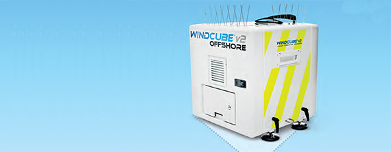
WINDCUBE® v2 Offshore
Thermal Imaging Camera
A Thermal Imaging Camera is able to obtain surface temperature maps by collecting infrared radiation data. With the use of this technology we can reduce energy waste and heat dispersion. Its use can be varied:
- Search for defective photovoltaic cells;
- Energy diagnosis of building/plant;
- Check operation of thermal and electrical systems;
- Check thermal bridges and correct heat dispersion;
- Search for rising moisture;
- Mapping of detachment of plaster and tiles;
- Determine wall texture and structural defects.
- Search for areas at risk for condensation /mold and infiltration;
- Mapping of thermo-hydraulic systems;
- Investigate infiltration and thermo-hydraulic leaks.
The heat detected by a thermal camera is quantified in a very precise way, allowing temperature variations to be monitored and identifying and evaluating the severity of heat-related problems.
Thermography thus enables accurate estimation of the amplitude and location of defective photovoltaic cells, or thermal bridges, etc. … providing important data which can be used to improve performance.
Request Rental of Termocamera – FLIER E60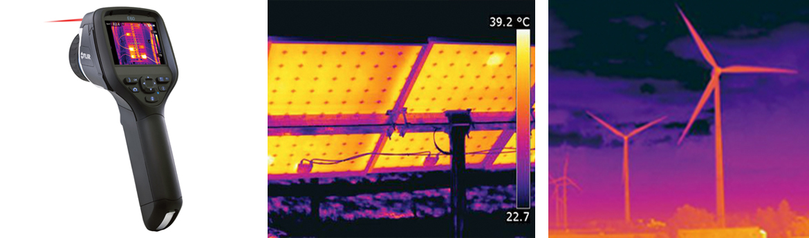 Thermal Imaging Camera – FLIER E60
Anemometers
An anemometers is a tool used to measure wind velocity or pressure. Le Towers can be either tubular or lattice construction, with a height ranging between 18 and 140 m. Two anemometers are mounted on the towers, as well as wind, density and humidity sensors, which are calibrated and certified, and data loggers for data collection and for remote monitoring.
The poles are installed without any foundation work, but simply put in the ground with appropriate pegs and cables. The data logger records the data from the sensors, which are then periodically extracted and processed using programs that determine the most significant parameters (speed, turbulence, direction) for calculating windiness and plant productivity. The structures can withstand winds of up to 160 km / h.
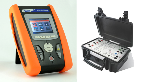 Photovoltaic Tester: Solar 300N – MPP300
Photovoltaic Tester
SOAVE Engineering provides PV testers, HT SOALR300N and HT MPP300, for measuring and recording the efficiency of a single and three-phase, single and multi-string photovoltaic system.
The SOLAR300N performs photovoltaic testing, which, after a synchronization phase, independently registers the irradiation and temperature values which are then transferred to the master unit when the test is finished. Instead, the MPP300 is an optional accessory which can simultaneously test single, threephase, and multi-string photovoltaic systems (up to three MPPT) in accordance with the requirements of the CEI 82-25 Guide.
MPP300 in combination with a master device is the ideal solution for monitoring and analyzing possible problems related to low efficiency values of photovoltaic installations.
Softwares
- ENERGY
- ENVIRONMENT
- VISUALIZATION
- GRID
- ECONOMY
The ENERGY module processes anemologic data collected through:
- Importing raw wind data, analysis, validation and calculation;
- Interfacing with WAsP and CFD models. Wind resource mapping and wind statistic calculation;
- Measuring- Correlating – Predicting and Generating wind statistics;
- Analysis of losses and uncertainties, and calculation of net production;
- Site suitability assessment for wind turbines and site layout;
- Automatic layout optimization to maximize production, with or without restrictions on noise output;
- Calculation of wind park production, including losses, turbulence calculations and RIX;
ENVIRONMENT module:
- Environmental Impact Analysis for each Sensitive Point;
- Noise calculations, with specific models for different countries;
- Advanced noise calculations;
- The SHADOW module calculates the annual hours of shadow flicker impact generated by one or more WTGs at either specified recipients or for a given area;
- Calculates visual impact in a region or long distance radar interference;
VISUALIZATION module:
- Create animated photomontages;
- Create a realistic photomontage of a wind farm before it is installed;
- The 3D-ANIMATOR module is used for virtual reality (VR) modeling of any given wind turbine project and any 3D objects;
GRID module:
- Design and calculation of WTG grid integration;
ECONOMY module:
- Calculate the financial or economic feasibility of the wind turbine/-farm investment in question;
WinROAD software is designed to solve topographic issues, as well as 3D modeling of terrain, road design and design of technological networks.
It is based on three-dimensional terrain modeling, from which it is possible to automatically extract the calculations that are the basis of the design: dimensions, contour plan, sections, profiles, volume calculation, 3D models using triangular or rectangular meshes, prospective views and rendering.
In addition, the road module allows complete management of the plano-altimetric map and the cross- sections of the road bed, using the project developed by the topographic module as the cartographic and topographic basis.
CerTus is ACCA’s response to construction site safety problems, the modular solution for organization, design and coordination, risk assessment, cost estimation, prevention, surveillance and control..
Directly from the guided study of the construction site, CerTus produces all the documents required by the Safety Codes and the guidelines of the Regions and Competent Bodies:
- Security and Coordination Plan;
- Operational safety plan;
- Security Plan Substitution;
- Combined risk & interference assessment report (D.U.V.R.I.) (“Documento Unico di Valutazione dei Rischi da Interferenza”) to be adopted at all sites where the Safety Coordinator is not present;
- Work file (for risk prevention and protection);
- Project Schedule (GANTT Chart);
- Estimated safety costs;
- Risk Assessment Reports according to code: Noise, Vibrations, Manual Load Handling, Chemical, Cancerogenous and Mutagen, Biological, etc;
- Safety Data Sheets (of dangerous preparations and substances);
- Technical Sheet on Excavations “(importing plans and maps created with other CAD to CerTus; CerTus-PRO functions are required for design of excavation area);
- Security Work Report “(to verify Security and Coordination Plan) with check-list;
- Technical Report of Coverage “for safely maintaining coverage;
- Emergency Evacuation Plan;
- Technical Guidelines for road construction signs in accordance with the Ministerial Guidelines;
- Combined risk & interference assessment report (D.U.V.R.I.) for providing concrete on site, in accordance with the Memorandum MLPS of 25 January 2011;
- All paperwork for safety coordinators (record of site visits, communication with supervisory bodies, etc.);
- All the paperwork for businesses (training, DPI delivery receipts, letters of transmittal, etc.).
Complete software for computing and accounting for project management, integrating all documents for project and project management:
- Price lists with unit rates;
- QS Quantity Survey;
- Job estimates;
- Requests for proposals;
- Comparison table;
- Project documents and templates;
- Labor incidence estimate;
- Technical specifications;
- Bill of Quantity book;
- Accounting register;
- Cost summary;
- Work progress statement;
- Payment Certificate;
- Steel reinforcement bar requirements book;
- Weekly lists of workers, equipment and costs;
- Final accounting.
PiMUS is a program by ACCA to process all required documents needed for the installation and use of scaffolding on site. The program can be used to create a general scaffold plan in line with requirements and regulations and to check scaffolding before assembly and during use.
TerMus CE is an energy certification software for all types of buildings (residential and non-residential – existing and newly constructed) without surface limits. It is updated according to the calculation methodology contained in UNI / TS 11300 technical standards.
The software draws up the Energy Performance Certificate (EPC) according to the National Guidelines (Decree 26 June 2009), and is the first software to have obtained certification from the Italian Thermotechnical Committee for compliance with UNI / TS 11300-1: 2014, UNI / TS11300-2: 2014, UNI / TS 11300-3: 2010, UNI / TS 11300-4: 2012, CTI R14: 2013 Recommendation and the EN standards referred to as UNI / TS 11300 and Dlgs. 192/05 art. 11 paragraph 1.
TerMUS calculates the following performance indicators:
- Net energy requirements for heating and cooling EEI;
- Energy requirements for heating, hot water and electrical;
- Quantità di CO2 prodotta;
- Economic savings obtainable and simple return time of potential investment;
- Energy Rating (from G to A+).
For calculation of Thermal Transmittance and Glaser diagram of Walls, Solai and surfaces with windows.
Solarius-PV simplifies the design and optimization of photovoltaic systems connected to the grid.
The software supports the design of low-voltage single-phase inverters (LV), and three-phase inverters in low (LV) and medium voltage (MV) through the customization of plants with multi MPPT inverters.
With this software is possibile to:
- Calculate the effects of PV shading from photo-panorama surveys;
- Calculate the PV system’s overall performance (total annual production with an hourly production rate schedule) and assess the profitability and amortization period of the entire photovoltaic system;
- Complete and reliable photovoltaic economic simulator for professional economic analysis (business plan), also without taking into account state incentives;
- Energy balance of plant with comparison of energy produced and energy consumed.
The software for structural calculation CDS is a powerful tool that allows you to carry out, with a three-dimensional schematization, an analysis of any structure by using the most sophisticated FEM techniques (Finite Element Method). CDS can model and calculate the spatial structures or levels with one-dimensional and two-dimensional elements (beams, columns, partitions, slabs, footings, pile footings, slabs, slabs on piles, nuclei stiffening).
Spatial data management tool.
Global Mapper works simultaneously on altimetric and vector data of any type, merging them together, and integrating them with the most popular raster formats.
It allows direct, contemporary access to images, topographic maps and altimeter data in grid format, and converts, edits, prints, and tracks positions located by GPS.
It also accesses WMS (Web Map Server) data sources, including access to world-wide altimeter and color data (eg N.A.S.A, DigitalGlobe, etc.). Data can also be represented by Global Mapper in a three-dimensional view, 3D model, where all possible raster and vector images are spread.
It’s much more than a simple program, and includes among its features:
- The calculation of areas and distances;
- Fusion of raster images;
- The management of their transparency;
- Spectral analysis and automatic contrast correction;
- The consultation of altimeter data;
- Calculating the longitudinal profile between points assigned;
- Volume calculation;
- Image rectification;
- The ability to generate, from the three-dimensional terrain model, both the level curves and the areas of visibility analysis (also called the Fresnel method), the comparison between three-dimensional models (including subtraction), triangulation and grid generation 3D with three-dimensional points.
The first software dedicated to design, documentation and technical drawing, it is mainly used to produce bi/ tri-dimensional engineering, architectural, mechanical, electrical drawings and so on. The file produced is vectorial, which allows, unlike what happens in raster graphics, to scale and enlarge them indefinitely without loss of resolution. AutoCAD also allows you to create three-dimensional models of geometric objects in vector mode.
This software is also used for design and technical drawings, but unlike the previous one, it allows you to work using both 2D and 3D rendering. Plants, sections, prospectives, lists of materials and other works are generated directly from the program based on the three-dimensional model of the building, and are updated in real time.
DOCFA is software for the compilation of technical cadastral documents and prepares the forms to verify ownership of urban real estate. With this form, you can present to the Cadastral office:
- New cadastral parcels;
- Cadastral variations of existing buildings (such as use, division, splitting, extensions, restructurings and other variations);
- Declaration of units to local authorities.
PREGEO (Pre-Treatment of GEOmetric Acts) is software that allows professional technicians to carry out cartographic upgrades and censuses related to land cadastre.
In particular:
- maps (adding new buildings to maps);
- Parcels;
- Splitting (division of land parcels).